GEOLOGY TELLS THE STORY OF THE ORIGIN AND DEVELOPMENT OF LAKE SAIMAA
The bedrock in the Saimaa Geopark area consists of types of rock that were formed approximately 1.9–1.6 billion years ago. This means that the bedrock was formed during the Paleoproterozoic Era. The bedrock is covered by loose Quaternary sediments deposited during the last 20,000 years. Read more about the geology of the area in this file: Bedrock and quaternary deposits in the Saimaa Geopark area.
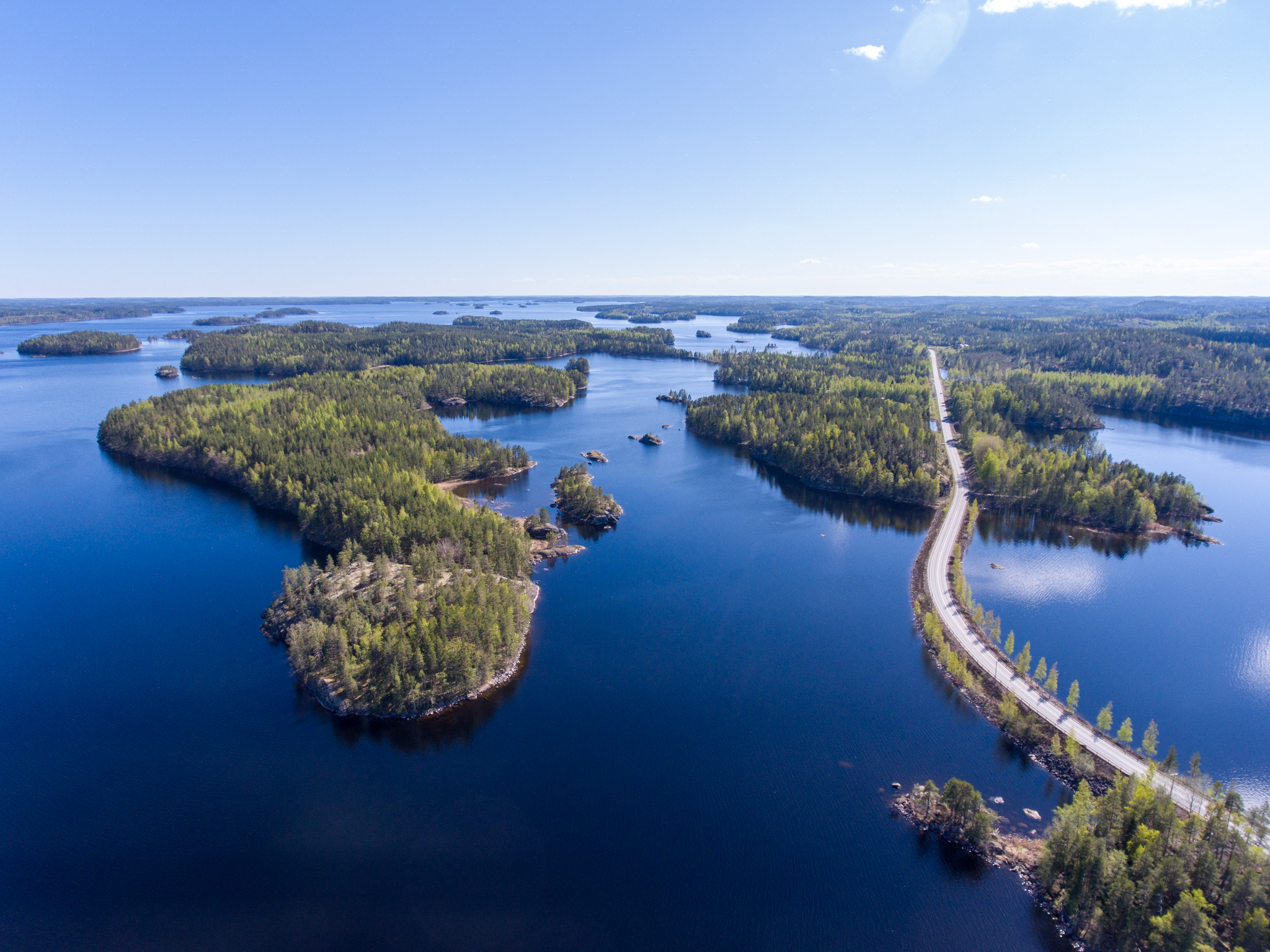
Salpausselkä ice-marginal formations
In the final stages of the Ice Age about 12,800 years ago a cold climate period took place, known as Younger Dryas. During the cool period, the receding of the melting ice sheet slowed down and, at some points, stopped completely. The First and Second Salpausselkä ice-marginal formations, which can be seen even from space, were formed 12,300–12,100 and 11,800–11,600 years ago when the edge of the glacier stayed in the same area. The melting ice transported rock material and deposited it as till, gravel and sand. At Salpausselkä’s, boulder-rich ice-marginal moraine is distinctive at the proximal side, the distal side being characterized by delta-forming sand and gravel. As a remnant from the labour of the glacier, two large-scale banks lie on the Saimaa area, interspersed by here and there meandering regions of eskers and kettle terrains. The great Baltic Ice Lake had formed from the glacial melt waters. The melting process transported the finest material to open waters, which then deposited and formed layers of varved clay.
Scale model of the Salpausselkä ice-marginal formation
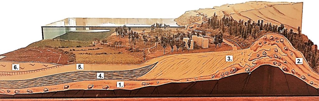
1. Ground moraine
The flowing ice eroded boulders and smithereens out of the bedrock. When the ice melted away, the rocky material was deposited as dense ground moraine which covers most of the bedrock in Finland, typically as a layer a few meters thick.
2. Ice-marginal moraine
The ice-marginal moraine was deposited when the Salpausselkä’s were formed. It typically consists of sandy and rocky till placed by the glacier at its edge.
3. Sand and gravel
The melt waters of the glacier transported and sorted material the same way as rivers do, forming gentle-sloping sandy deltas at the distal side of the Salpausselkä’s. Eskers consist of gravel and sand, deposited in meltwater tunnels inside the glacier. Today, delta and esker territories are important sources of sand and gravel.
4. Varved clay (glacial clay)
The melt waters of the ice sheet transported the finest material far out to the open waters. When it accumulated, deposits of varved clay were formed. The continuous layers (or varves) are connected to seasonal variation: dark thin layers were formed in wintertimes when the melting was slow and pale thicker layers in summertimes when the melting accelerated.
5. Post-glacial clay
Clays that were deposited after the glacier was melted are called post-glacial. They have no layered structure and they contain more organic matter than glacial clay.
6. Peat
Peat is a soil type that consists of incompletely degraded organic material which accumulates in marsh areas. The first peat lands in Finland started to form locally quite soon after the land was set free from ice and the low-lying territories were uncovered from water.
Continental ice sheet and Imatra State Hotel
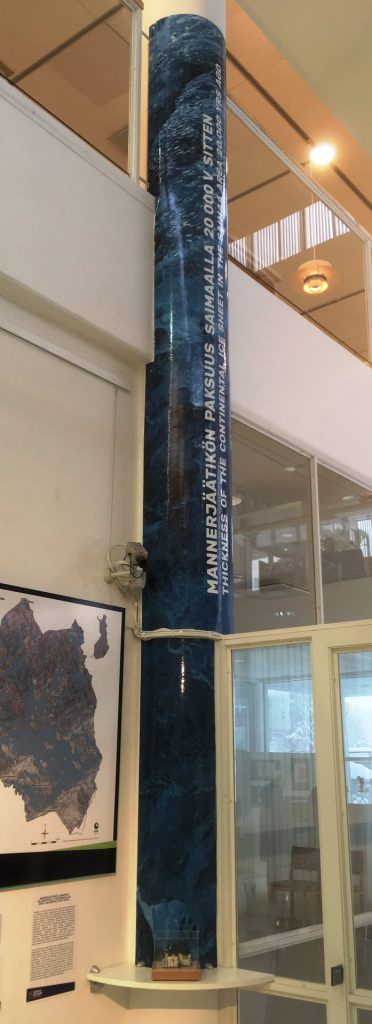
During the last two million years, cyclic glaciations have dominated especially the northern hemisphere of our planet. The last of them, the Veiksel glaciation, began in Europe when the climate cooled approximately 118,000 years ago and the continental ice sheet started to grow in Scandinavia. The glacier had extended to its maximum, to Middle Europe approx. 25,000 years ago. At that time, the ice covered the whole Finland’s area as a two-kilometers thick bed. The maximum thickness of the glacier is expressed in the adjacent pillar on a scale of 1:500. At the feet of the ice pillar, on the same scale, is a model of the State hotel which is located by Imatrankoski rapids. The Statehotel, originally Grand Hotel Cascade, has been built in 1903 and it is a graceful historical attraction. It represents the Jugend style, typical for its time and it has been designed by architect Usko Nyström.
The erosion forms of the glacier
During the Weichselian last glaciation maximum, the continental ice sheet extended to Middle-Europe approx. 20,000 years ago. For tens of thousands of years, the glacier eroded its base and these erosional marks are still visible in our landscape. The glaciation center was located at the Bothnian Bay, from where the ice slowly flowed towards its margins. Enormous pressure was present at the bottom of the glacier and the flowing ice mass broke and crumbled rock material from the bedrock. It has been estimated that during the last glaciation the ice eroded our bedrock as much as seven meters on average. In many areas the rock load at the bottom polished rocky hills to rôche moutonnées. The glacier ground the fragile zones of the bedrock to gulleys and erosion valleys. Today, many of these can be seen in the landscape as longitudinal, steep-sloped lakes, showing the direction of the ice flow. Similarly, many zones of especially hard rocks have remained as hills, rising from their surroundings.
Drumlins and flutings
In the areas of active ice flow, till deposited in the direction of the flow, forming longitudinal moraine ridges called drumlins and flutings. Drumlins are typically few meters tall and droplet-shaped formations that can extend up to few kilometers in length. In many cases, crescent troughs can be found in front of them. Flutings are similar formations but they are linear and smaller in height. These two kinds of moraine ridges are present as fan-like fields in many areas. Different suggestions about the exact mechanism of their formation have been proposed but it has been noticed that they often have a rocky core in their topside head. According to the generally accepted theory, the ridges have formed when the flowing glacier deposited its rocky bed load behind a strong obstacle.
Esker sand
Sand is a sorted soil type whose grain size variation is relatively even. Sands are deposited at beaches and river environments because of the streaming and sorting action of water. In the Ice Age, enormous quantities of sand was deposited in melt water ravines and deltas of the glacier. The melt waters on the ice surface caved tunnels through the glacier and strong rapids transported the material the glacier had captured. When the currents calmed near the edge of the glacier, the sandy material was deposited on the riverbed. When the glacier melted down and its edge receded the sand deposits were left behind and can now be seen in the landscape as longitudinal esker formations. In front of the ice sheet, at the river outlet channels, the sand formed delta areas. Sand and gravel formations are our best ground water sources.
Grain size: 0.2–2.0 mm
Esker boulders
During the melting phase of the continental ice sheet, boulders stocked in glacial rivers which flowed inside the ice. In some places the strong currents lasted for centuries, whetting stones to rounded esker boulders. These symphatic rock spheres can be found on esker terrains but also elsewhere, where they have been transported by the ice.
Esker gravel
Gravel, like sand, is a well sorted soil type. Esker gravel was deposited in the glacial melt water tunnels by strong currents. It is typical that the core of the eskers in composed of coarser material than the upper parts, even boulders. This kind of structure is a result from the fact that when the eskers started to form the flow velocity was often high and was able to deliver bigger rocks. The strong current eroded the stones and, because of this eroding ability of streaming water, the esker gravel clasts are rounded. While the gravel-sized particles were deposited the finer material still drifted with the current, to be deposited in some place else with calmer flowing conditions.
Grain size: 2–20 mm
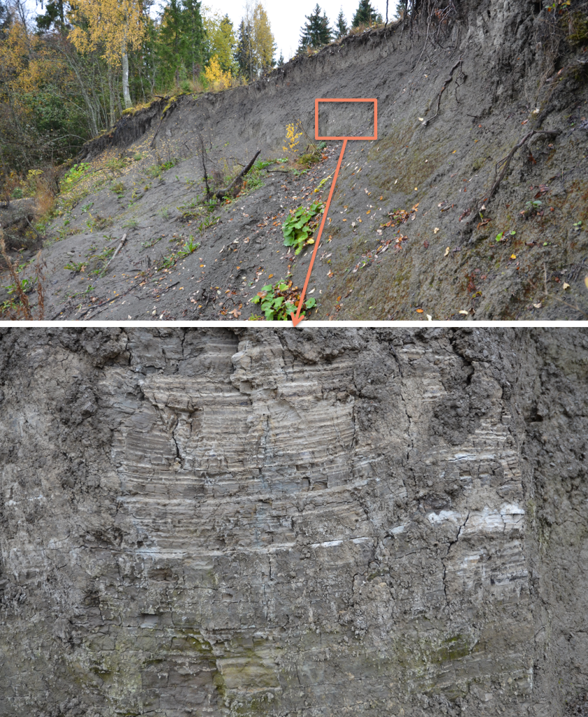
Varved clay
The melt waters from the glacier transported fine material which did not immediately sink to the bottom but drifted along with the current to the open waters before finally descending down to the bottom of the Baltic Ice Lake. Thus, the clay terrains in Finland have been deep-water stratification environments. The varved clay or glacial clay deposits consist of continuous layers of pale and dark material. The layers resemble the growth rings of trees. The pale layers have formed in summertime when the melting of the ice accelerated, while the more fine-grained layers formed in wintertime when the melting correspondingly slowed down.
Grain size: < 0.002 mm
Glacial till
Till is our most common soil type. It is unsorted or poorly sorted soil type, meaning that it contains all grain sizes from clay to big boulders in variating ratios. There is not flowing water action related to the deposition of glacial till formations (or moraines) because till is material mechanically eroded by glacier and after the glacier melted away the material was deposited in situ. Because there has not been eroding action of water the clasts are typically poorly rounded. Many of our terrain shapes are consisted of till, for instance the great ice-marginal moraines of the Salpausselkä’s and the droplet-shaped drumlins following the flow direction of the ice. Most of our bedrock is covered by ground moraine, composed of the material crumbled and deposited beneath the glacier.
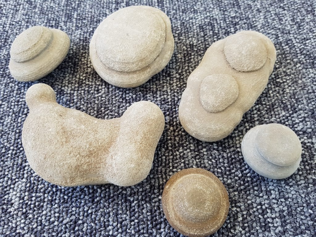
Imatra stones
On the river banks of Mellonlahti and Vallinkoski one can find strange light-coloured pebbles called Imatra stones. They are chalk coagulates, formed in clay deposits of Vuoksi area during the melting phase of the continental ice sheet. When porous fine-grained layers contained enough carbon dioxide and bicarbonate local oversaturation lead to concretion of calcium carbonate. As a result, strange-shaped limestone pebbles were formed. Once Imatra stones were sold as souveniers but nowadays collecting them is forbidden. The stones exhibited in visitor centre’s vitrine are received from the collections of the Imatra Town Museum.