FROM THE BIRTH OF SAIMAA TO THE PRESENT DAY
The foundations of the Saimaa landscape were laid at the bottom of the ancient sea more than 1900 million years ago. The mica gneiss and its related rock types were formed from the clay, silt and mud deposited on the sea floor. 1 885 million years ago, the collision of the plates of the Earth's rocky crust gave rise to the ancient mountain range, where the marine deposits were transformed into mica gneiss and vein gneiss in the foothills. The granitic rocks of the Saimaa area were formed between 1 830 and 1 800 million years ago. At that time, hundreds of cubic kilometres of granitic rock melt slowly crystallised into coarse-grained granite deep in the foothills. Over time, the mountain was eroded away and is now sand on the shores of Lake Saimaa. The broken bedrock of the mountain range is still visible as a mosaic-like landscape, alternating between water and rocky and terrestrial areas.
Salpausselkä ridges can be seen from space
The southern part of Saimaa became a separate lake basin around 11 000 years ago and the basins in the northern part of the Saimaa Geopark area around 10 700 years ago. As a reminder of the last Ice Age, Saimaa is criss-crossed by the mighty chains of marginal formations, the Salpausselät, which were formed around 12 300-11 600 years ago and are visible in space. The land beneath the continental shelf is still rising and gradually changing its shoreline. The tilting of the land is evidenced by the ancient forests and prehistoric settlements along the shore of Lake Saimaa.
Vuoksi, the great current, was born from an ancient natural disaster
The waters of Lake Saimaa initially flowed into the Gulf of Bothnia. The land released from the continental pressure rose faster in the Gulf of Bothnia and the land began to tilt towards south-east Finland. On the Saimaa, the waters flooded against the Salpausselkä, and about 5 700 years ago the mighty Salpausselkä rim broke and the Saimaa gushed out as a wide river onto dry land. Vuoksi, the river that flows down the Saimaa, was born.
Today's Vuoksi, which flows into Laatokka, is the largest river in Finland. Imatra, the largest rapids of the Vuoksi, has attracted tourists to its shores for centuries.
Saimaa has unique wildlife
A legacy of the isolation brought about by the Ice Age are the endemic species of Lake Saimaa that cannot be seen anywhere else in the world. There are approx. 430 of the likeable Saimaa ringed seals (Pusa hispida saimensis) left. If you are lucky, you may see the jovial seal laying on a rock and basking in the sun. Two of the fish species, the landlocked salmon (Salmo salar m. sebago) and the Arctic char (Salvelinus alpinus), are local and critically endangered.
The shores have been inhabited since prehistoric times
Humans arrived in Saimaa over 10,000 years ago. Great waters for fishing and land for hunting attracted people to this new area that had been revealed from under the ice. The most popular settlement spots were near the sunny beaches. People painted dozens of rock paintings on cliffs and rocks, with the most common subjects being people, animals and boats. The paintings tell us about the world of the ancient hunters of Saimaa.
Saimaa is at the border between east and west
During the Second World War, a 1,200 kilometre-long defence zone, called Salpalinja, was built in Finland. It was one of the strongest defensive positions of the war. The most densely fortified area was Saimaa, where defences can still be seen on the shores and islands. With the Moscow Peace Treaty (1940), Finland’s eastern border shifted and part of the Vuoksi River and the waterway connection from Saimaa via the Saimaa Canal to the sea remained on the Soviet side of the border. These days Finland leases the Saimaa Canal from Russia.
The ancient waterway is still in use
The waters of Saimaa have acted as an important transport route since prehistoric times. They have made it possible to transport raw material for the needs of the wood processing industry, which is very important for Finland. Saimaa still has active commercial traffic that consists of cargo carriers and cruise ships. The Saimaa Canal offers an aquatic connection to the Gulf of Finland, apart from a couple of months in the winter when the canal freezes. In the summertime, towboats transporting timber and log rafts hundreds of metres in length can be seen slowly floating towards paper mills.
Saimaa is a good place to live
Living the life of an islander has a strong cultural meaning in Saimaa. Cities and small villages grew up near the water. Bridges and ferry boats connect those that live in the fragmented archipelago. Life in the countryside relies on agriculture, forestry and the service industry. Some of the residents work in the cities in the area and in the summer they might commute by boat. Ring cold winters, you can take a short cut across the lake via an ice road.
Saimaa is a popular holiday destination. All year round, summer cottages, waterways and forests offer a wide range of opportunities for relaxing and experiencing new things in the middle of the countryside, while still remaining close to the city.
THE BALTIC SEA PHASES
The Saimaa Geopark area took about a thousand years to free itself from the ice sheet. The area was part of the ancient lake and sea phases of the Baltic Sea before it became an independent lake basin. Around 11,000 years ago, the water level in southern Lake Saimaa was much lower than today, but uneven land uplift and the resulting tilting of the crust to the south-east, together with the northern position of the first estuary, contributed to coastal flooding. Lake Saimaa was at its widest during the Suur-Saimaa phase. The eruption of River Vuoksi 5,700 years ago changed the course of Lake Saimaa's development. The water level dropped by a few metres and River Vuoksi began to regulate the development of Lake Saimaa and the lake landscape of Eastern Finland. For today's hikers, the multi-phase history of Lake Saimaa can be seen in the form of raised beaches of different altitudes.
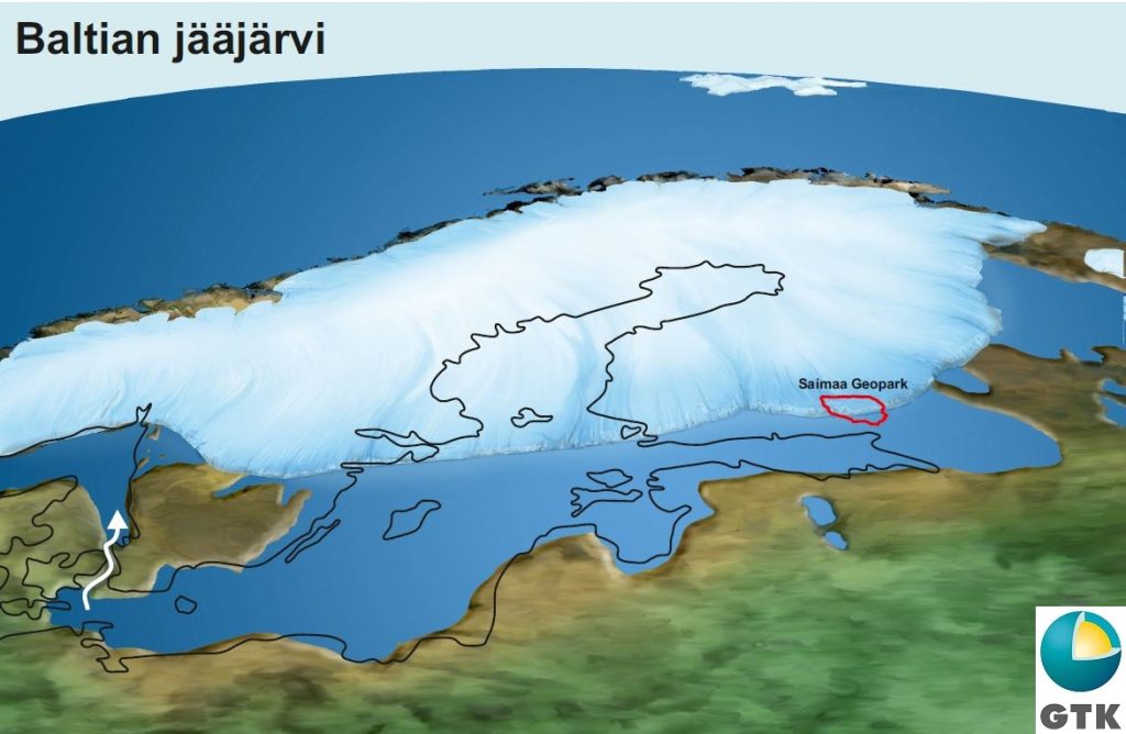
The Baltic Ice Lake
The First and the Second Salpausselkä were deposited at the margin of the continental ice sheet that remained at the same area between 12,300-12,100 and 11,800-11,600 years ago. At that time meltwaters from the ice sheet flowed into the Baltic Ice Lake. The outlet channel to the ocean was located at the present-day Straits of Denmark.
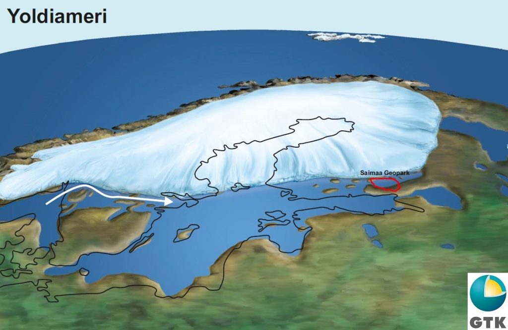
Local ice lakes and Yoldia Sea
A sea connection from the Baltic Ice Lake to the ocean opened via central Sweden approximately 11,590 years ago. The water level dropped 26-28 metres and saline waters flooded into the Baltic basin where the next stage, Yoldia Sea started. After the drop of the water level of the Baltic Ice Lake there were local ice lakes in the Saimaa area. That phase lasted a couple of centuries. The Yoldia Sea spread to the Geopark area as narrow bays until c. 11,400 years ago.
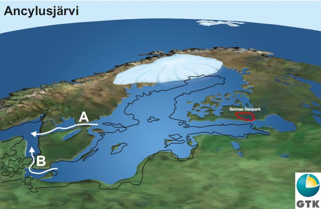
From Yoldia Sea to Ancylus Lake
Because of the land uplifting the Yoldia Sea became isolated from the ocean approximately 10,700 years ago. The next stage in the Baltic basin was Ancylus Lake. The first outlet channel of Ancylus Lake (A) shifted from central Sweden to the location of present-day Straits of Denmark (B) over 10,000 years ago.
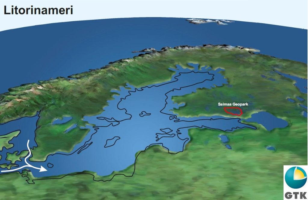
Ancylus Lake is changed to Litorina Sea
Approximately 9,000 years ago the ocean level was so high due to the meltwaters from the northern hemisphere glaciers that saline waters flooded through the Straits of Denmark into Ancylus Lake. In the Baltic basin, the Litorina Sea stage started. The Litorina Sea didn´t reach Saimaa.